|
Legend |
|
 |
|
Bridgend County Borough Boundary/Plan Area |
|
 |
|
Glamorgan Heritage Coast (EV9) |
|
 |
|
Kenfig National Nature Reserve (EV18(B)) |
|
 |
|
Strategic Coalfield Plateau & Associated Valley Sides (EV10(1)) |
 |
|
Landscape Conservation Area (EV10(2)) |
 |
|
Green Wedge (EV11) |
 |
|
Settlement Boundary (EV12) |
 |
|
Coastal Zone Boundary (EV15) |
 |
|
Site of Special Scientific Interest (EV18(B)) |
 |
|
Existing Local Nature Reserve (EV19) |
 |
|
Proposed Local Nature Reserve or RIGS (EV19) |
 |
Conservation Area (EV37, EV38,
EV39, EV40, EV41)
The following Policy also applies to certain Conservation Areas:- Policy (T14) |
 |
|
Historic Park/Gardens (EV42(a)) |
 |
|
Historic Park/Garden Essential Setting (EV42(A)) |
 |
|
Historic Landscapes (EV42(B)) |
 |
|
Residential Development (H1) |
 |
|
Employment Development (E2, E3,
E4, E5, E6, E7 &
E10) |
 |
|
Lorry Park (T10) |
 |
|
Rail Freight Terminal (T11) |
 |
|
Transport Corridor (T13) |
 |
|
Major Improvement to Highway Network - Defined (T14) |
 |
|
Major Improvements to Highway Network - Undefined (T14) |
 |
|
Extension to Bus Station (T15) |
 |
|
Transport Interchange (T16) |
 |
|
Improvements to Passenger Railway Network - Defined (T17) |
 |
|
Improvements to Passenger Railway Network - Undefined (T17) |
 |
|
Off Street Car Parking (T19) |
 |
Established Commercial Centre (R1, R2)
The following Policies also apply to all established commercial centres:-
Policies (E10; T14, T17;
R4, R5, R6, R7,
R8).
Additionally, Policies (R3; T8, T15,
T16,
T19; REG1) apply to the established commercial centres of Bridgend, Maesteg &
Porthcawl only. |
 |
Prime Shopping Street Frontage (R3)
The following Policies apply to all prime shopping street frontages:1 Policies
(R3, R4; REG1) |
 |
|
Retail Redevelopment Site in Established Commercial Centre (R8) |
 |
|
Established Large Scale Out-of-Town Retail Site (R10) |
 |
|
Designer Outlet - Wales (R11) |
 |
|
Serviced Accommodation Are, Porthcawl (TM8) |
 |
|
Playing Field (RC6) & Amenity Open Space Area (RC9) |
 |
|
Informal Recreation Facility (RC10) |
 |
|
Community Route (RC11) |
 |
|
National Cycle Route (RC13) |
 |
|
Indoor Recreation Facility (RC16) |
 |
|
Social, Health, Educational & Community Facility (SC4,
SC5, SC6) |
 |
|
Special Areas of Conservation (SACs) (various status) (E18(A)) |
 |
|
Sand and Gravel Resource Safeguarding Area (M14) |
 |
|
Mineral Exploration Site - Quarry Boundary |
 |
|
Future Mineral Development - Safeguarded Area (M4) |
 |
|
Future Mineral Development - Area of Search (M5) |
 |
|
Mineral Protection Zones (M11) |
 |
|
Mineral Plan - Retention of Land (M12) |
 |
|
Landfill Site (W2) |
 |
|
Regeneration Sites (REG3) |
|
Legend in PDF format 23.6Mbs) |
|
Please be aware of download times using 56K modem 1Mb=approx. 30s |
|
© Crown copyright. Bridgend County Borough Council Licence No 100023405 2005 |
 Obtain a free copy of Adobe Acrobat Reader®. This link opens in a new browser window Obtain a free copy of Adobe Acrobat Reader®. This link opens in a new browser window |
|
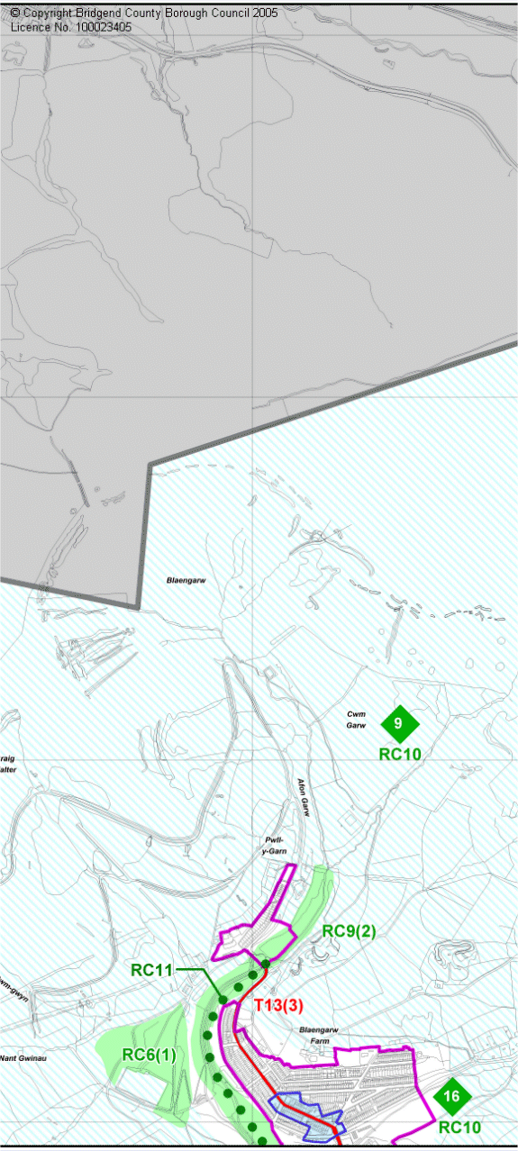
Proposals Map 2 - Central
To open an Adobe Acrobat PDF version of this map click on the link to the
left. PDF files enable panning and zooming of the map to see much greater
detail and clarity than can be seen on the image below. To download a copy
of the PDF file to your machine use the right button of the mouse on the link
and select 'Save Target as..'
|
 |
The following Unitary Development Plan Part 2 Policies apply to the whole
County Borough:-
Policies
EV1,
EV2,
EV3,
EV4,
EV5,
EV6,
EV7,
EV8,
EV13,
EV17,
EV20,
EV21,
EV22,
EV23,
EV24,
EV25,
EV26,
EV27,
EV28,
EV29,
EV30,
EV31,
EV32,
EV33,
EV34,
EV35,
EV36,
EV37,
EV38,
EV39,
EV40,
EV41,
EV43,
EV44,
EV45,
EV46,
EV47,
EV48;
H2,
H3,
H4,
H5,
H6,
H7,
H8;
E1,
E9,
E11,
E12,
E13,
E14,
E15;
T1,
T2,
T3,
T4,
T5,
T6,
T7,
T8,
T9,
T10,
T11,
T12;
R1,
R9;
TM1,
TM2,
TM3,
TM4,
TM6
RC1,
RC2,
RC3,
RC4,
RC5,
RC7,
RC8,
RC9,
RC12,
RC14,
RC15;
SC1,
SC2,
SC3,
SC8
M1,
M2,
M3,
M6,
M7,
M8,
M9,
M10,
M13;
W3,
W4,
W5,
W6,
W7,
W8,
W9,
W10;
UNS1;
U1,
U2,
U3,
U4,
U5,
U6,
U7,
U8,
U9,
U10;
and REG1,
REG2. |
|