|
Legend |
|
 |
|
Bridgend County Borough Boundary/Plan Area |
|
 |
|
Glamorgan Heritage Coast (EV9) |
|
 |
|
Kenfig National Nature Reserve (EV18(B)) |
|
 |
|
Strategic Coalfield Plateau & Associated Valley Sides (EV10(1)) |
 |
|
Landscape Conservation Area (EV10(2)) |
 |
|
Green Wedge (EV11) |
 |
|
Settlement Boundary (EV12) |
 |
|
Coastal Zone Boundary (EV15) |
 |
|
Site of Special Scientific Interest (EV18(B)) |
 |
|
Existing Local Nature Reserve (EV19) |
 |
|
Proposed Local Nature Reservce or RIGS (EV19) |
 |
Conservation Area (EV37, EV38,
EV39, EV40, EV41)
The following Policy also applies to certain Conservation Areas:- Policy (T14) |
 |
|
Historic Park/Gardens (EV42(a)) |
 |
|
Historic Park/Garden Essential Setting (EV42(A)) |
 |
|
Historic Landscapes (EV42(B)) |
 |
|
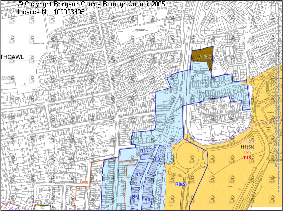
Residential Development (H1) |
 |
|
Employment Development (E2, E3,
E4, E5, E6, E7 &
E10) |
 |
|
Lorry Park (T10) |
 |
|
Rail Freight Terminal (T11) |
 |
|
Transport Corridor (T13) |
 |
|
Major Improvement to Highway Network - Defined (T14) |
 |
|
Major Improvements to Highway Network - Undefined (T14) |
 |
|
Extension to Bus Station (T15) |
 |
|
Transport Interchange (T16) |
 |
|
Improvements to Passenger Railway Network - Defined (T17) |
 |
|
Improvements to Passenger Railway Network - Undefined (T17) |
 |
|
Off Street Car Parking (T19) |
 |
Established Commercial Centre (R1, R2)
The following Policies also apply to all established commercial centres:-
Policies (E10; T14, T17;
R4, R5, R6, R7,
R8).
Additionally, Policies (R3; T8, T15,
T16,
T19; REG1) apply to the established commercial centres of Bridgend, Maesteg &
Porthcawl only. |
 |
Prime Shopping Street Frontage (R3)
The following Policies apply to all prime shopping street frontages:1 Policies
(R3, R4; REG1) |
 |
|
Retail Redevelopment Site in Established Commercial Centre (R8) |
 |
|
Established Large Scale Out-of-Town Retail Site (R10) |
 |
|
Designer Outlet - Wales (R11) |
 |
|
Serviced Accommodation Are, Porthcawl (TM8) |
 |
|
Playing Field (RC6) & Amenity Open Space Area (RC9) |
 |
|
Informal Recreation Facility (RC10) |
 |
|
Community Route (RC11) |
 |
|
National Cycle Route (RC13) |
 |
|
Indoor Recreation Facility (RC16) |
 |
|
Social, Health, Educational & Community Facility (SC4,
SC5, SC6) |
 |
|
Special Areas of Conservation (SACs) (various status) (E18(A)) |
 |
|
Sand and Gravel Resource Safeguarding Area (M14) |
 |
|
Mineral Exploration Site - Quarry Boundary |
 |
|
Future Mineral Development - Safeguarded Area (M4) |
 |
|
Future Mineral Development - Area of Search (M5) |
 |
|
Mineral Protection Zones (M11) |
 |
|
Mineral Plan - Retention of Land (M12) |
 |
|
Landfill Site (W2) |
 |
|
Regeneration Sites (REG3) |
|
Legend in PDF format 23.6Mbs) |
|
Please be aware of download times using 56K modem 1Mb=approx. 30s |
|
© Crown copyright. Bridgend County Borough Council Licence No 100023405 2005 |
 Obtain a free copy of Adobe Acrobat Reader®. This link opens in a new browser window Obtain a free copy of Adobe Acrobat Reader®. This link opens in a new browser window |